Share the post "Étape du Tour 2026: full reconnaissance"
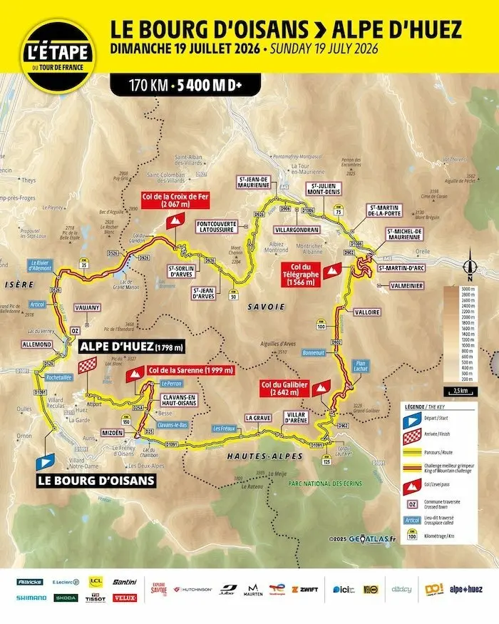
170 km, 5400 m D+, three legendary passes. Between Bourg-d’Oisans and Alpe d’Huez, the 2026 Étape du Tour plunges cyclosport riders back into the very essence of high mountain cycling: length, harshness, high altitude, and magnificent landscapes. Due to early snowfall on the Galibier at the end of October, we were unable to complete a single reconnaissance ride immediately after the route announcement. But we have ridden these roads dozens of times. We know where they breathe, where they trap you, where they elevate you. Here, we detail the 2026 Étape du Tour route, kilometer by kilometer, to help you prepare for it in the best possible conditions. Let’s go.
By David Polveroni – Photos: ©3bikes.fr, ©A.S.O., depositphotos.com
A touch of Marmotte, but A.S.O. style
We eagerly awaited it in front of our screens this Thursday, October 23rd. This year, little information had leaked; at 11 am, many unknowns remained. Then the verdict came: for some, the 2026 Étape du Tour route is too hard; for others, it marks the return of an authentic, demanding event, living up to the myth – a true return to the essence of cyclosport. And how can one doubt it? With over 5,000 m of positive elevation concentrated over 170 km, the route furiously resembles the legendary Marmotte… but with the A.S.O. organization’s touch. A dense, chiseled route, with no escape: the mountains, the real ones.
Barely 15 kilometers separate Bourg-d’Oisans (the start), nestled at the bottom of the valley, from Alpe d’Huez (the finish), perched on its sunny balcony. 15 kilometers and yet a whole world: that of cycling, history, suffering, and myth.
Alpe d’Huez is the legend of the Tour: inaugurated in 1952 with Fausto Coppi’s victory, it has become a symbol with its 21 numbered bends etched into the peloton’s memory. The resort had not hosted the men’s Tour since 2022, when Tom Pidcock won there after an epic descent of the Galibier. The 2023 Tour Femmes then wrote its own history, with a legendary mano a mano for victory between Katarzyna Niewiadoma and Demi Vollering, concluding its edition on these mythical slopes.
The return of the resort via the 2026 Étape du Tour therefore takes on a special resonance. No classic climb this time: the organizer chose the variant via the Col de Sarenne, wilder, rawer, almost secret. An indirect, but respectful, way to approach the legend of the Marmotte. Between Bourg-d’Oisans, the historic gateway to the great Alpine stages, and Alpe, “the island in the sun,” this route marks a true cycling pilgrimage. A condensed history, beauty, and personal challenge.
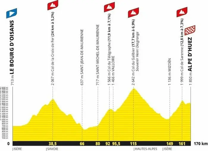
As with the famous Marmotte, your high mountain day on the 2026 Étape du Tour will be written in three acts, with the mythical ascents of the Croix de Fer, the Galibier and its Télégraphe stepping stone, and Sarenne before reaching the Alpe d’Huez resort. Three giants that should absolutely not be underestimated.
The Col de la Croix de Fer: the warm-up
Altitude: 2,067 m – 29 km – 1,600 m D+ – average gradient 5.2%
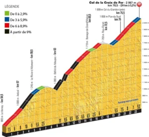
The start takes place, as for the Marmotte, on the D1091, this wide Alpine artery capable of absorbing the successive waves of cyclists setting off on Sunday, July 19th. The first kilometers fly by, carried by the excitement of the start and the long straight sections of the valley. After about 7 km, you need to turn right at Rochetaillée: a first point of vigilance, as the speed is still high at this point. You then enter the Eau d’Olle valley and the commune of Allemont, whose freshly resurfaced asphalt offers a perfect ride. At the exit of the village, a sign announces the color: “Col de la Croix de Fer: 29 km.” A first S-shaped ramp allows you to pass above the Verney dam. Then, for two to three kilometers, the road runs alongside the lake on a flat section, before leaving the climb to Vaujany on the right. A short descent, and you are in the real pass.
The Croix de Fer is a climb with character. If the legs are good, it can be a real pleasure; otherwise, it quickly turns into torture. Over nearly 29 km, everything is there: brutal ramps, deceptive flat sections, descents that break your rhythm, incessant accelerations. The gradients oscillate from -12% to +14%, making any reading of the pass difficult. It can be divided into three sections:
- The climb towards Rivier-d’Allemont: the first part is irregular: an initial ramp of nearly 10%, then flat sections that bring the average back to around 7%. The last three kilometers before Rivier are steeper, often around 9 to 10% after the small hamlet of Articol. This is generally where the first groups form and the most ambitious begin to “push the pace.” For others, the watchword remains simple: manage and fuel up. A small flat section allows for a breather before a short winding descent – five tight hairpins – leading to the next section.
- The central section up to the Grand’Maison dam: Here, the gradient rears up immediately: a very steep section, between 12 and 14%, over 300 to 400 meters. This is probably the hardest part of the entire Étape du Tour. Once past this “wall,” you rejoin the road rebuilt after the 1989 landslide. The gradient remains demanding, speed drops, the mountain closes in. The road winds through the mountain; gradually, the Grand’Maison dam appears – a second landmark at nearly 1,700 m altitude, already a significant step climbed. The road then runs alongside the lake on a rolling section (4 to 6%), conducive to recovery… or to pushing a bigger gear. Beware of the wind: this area is often exposed. From experience, a headwind here often extends into the Maurienne valley and up to the Galibier, but it offers a favorable tailwind on the descent of the Lautaret.
- The summit section up to the pass itself. There are then about 6 km left to reach the Croix de Fer. The percentages become more reasonable, between 5 and 7%, but the altitude makes itself felt. The scenery changes: you leave the woods for the high-altitude pastures, with the Grand’Maison lake below and the Trois Aiguilles d’Arves in the background. Two kilometers before the summit, you leave the Col du Glandon on the left, before the last open bends towards the summit cross. Here, it’s hard not to look up: it’s one of the most beautiful panoramas in the French Alps. For cyclos not racing the clock, a photo stop is mandatory.
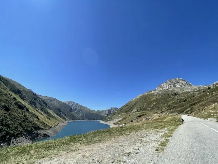
In summary, the Croix de Fer is a long, irregular, demanding, but splendid pass. It sets the tone for this entire Étape du Tour: manage, anticipate, conserve energy. At the top, accept it: you will have to be able to climb this twice more before the end of the day. The good advice? Never go into the red, except perhaps at the end of each section, to accelerate without blowing up. The rest is about clear-headedness, rhythm, and a lot of humility – as always in the mountains, but even more so this year.
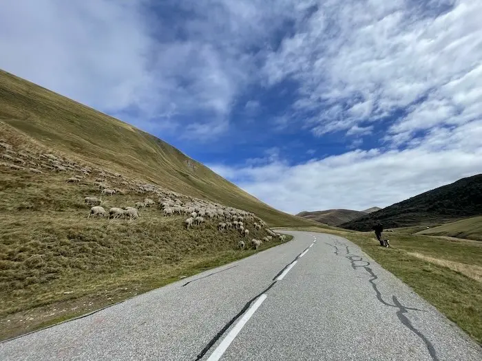
From Croix de Fer to Galibier: between vigilance and grandeur
The descent towards Saint-Jean-de-Maurienne takes place in three stages, with only one rule: caution. The descent of the Col de la Croix de Fer is divided into three distinct parts, each with its traps and nuances:
- The first 7 kilometers to Saint-Sorlin-d’Arves: a winding section over about 7 km. The road snakes without any vegetation, visibility is excellent, and the bends follow one another rhythmically. The road surface should be redone before summer, hopefully, especially through the village, where significant ruts in the asphalt make some sections dangerous. The gradient is constant, the setting magnificent, but it’s a descent where you must remain in control of your speed.
- The intermediate section: from Saint-Sorlin to Combe Bérard. After Saint-Sorlin, you enter a more rolling section. This is the ideal place to fill up with water at the fountain just in front of the town hall, before embarking on a straighter section. You leave the Col du Mollard turn-off on the right, then the road narrows slightly. A few meters of uphill allow you to pass through a small tunnel, short, without the need for lighting, but which leads to a tight bend. Behind it, the descent of the Combe Bérard opens up: a long, fluid ribbon, known to those who climbed this side during the 2022 Étape du Tour. Nothing treacherous here, but vigilance remains essential. The road encourages you to accelerate, wrongly. Serenity is the keyword.
- The last section: towards Saint-Jean-de-Maurienne. A short climb breaks the rhythm: no major difficulty, but sometimes you have to shift back to the small chainring to maintain fluidity. Behind it is the final big plunge towards Saint-Jean-de-Maurienne: a fast, fluid descent, with only one hairpin, where speeds easily exceed 70 km/h. The danger here is overconfidence. Keep your hands on the hoods, your eyes far ahead. At the bottom, the mountain fades, the valley opens.
Then begins a 13 km section of valley, a false flat leading up to Saint-Michel-de-Maurienne. This is the only real transition phase of the day. The watchword is simple: refuel and regenerate. Drink, eat, relax your shoulders, spin your legs. 83 km on the clock, but the halfway point is not yet reached. Another 12 km, and you can estimate your total Étape du Tour time.
The crossing of Saint-Michel-de-Maurienne marks the beginning of a new chapter. You leave the valley of the same name, cross the bridge over the Arc, and it’s time to tackle the 12 km of the Col du Télégraphe.
The Col du Télégraphe: the launch ramp
The Télégraphe is a gateway pass. An intermediate climb, certainly, but one that conditions everything that follows. It can be divided into two sections:
- 8 km of a gradient oscillating between 6 and 8.5%, up to the turn-off for Valmeinier
- Then a flat section, followed by 3.5 km of more rolling terrain, between 4.5 and 7%, a notch below.
It’s often here that the body is tested: legs still warm, head already in the Galibier. The last kilometer overlooks the Maurienne valley and offers that unique sensation of leaving the plain to return to the mountains. But make no mistake: the Télégraphe is just a prologue. It’s the launch ramp for the pass that built the legend of the Tour… Note that there is a water point at the summit.
The Col du Galibier: the altar of cycling
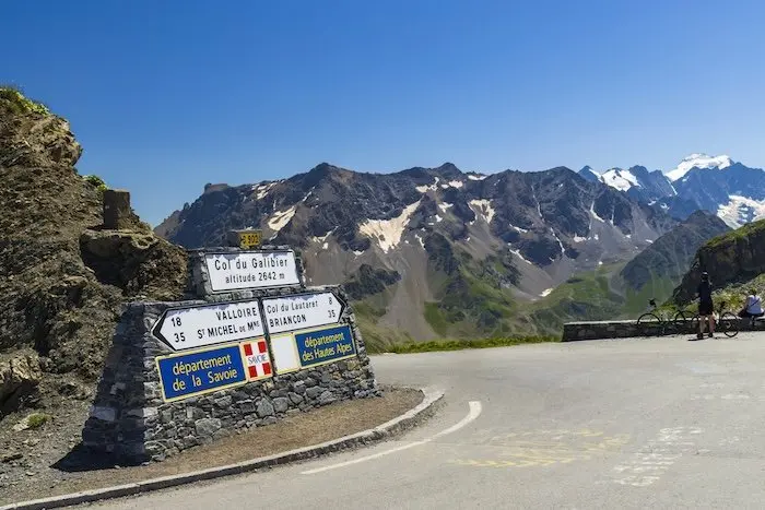
Altitude: 2,642 m – 34 km from Saint-Michel-de-Maurienne (17 from Valloire) – 1,924 m D+ – average gradient 5.5%
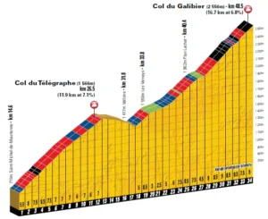
The giant of the Alps. After the short descent of the Télégraphe, you cross Valloire, its small cobblestones, its mountain atmosphere. If the vibrations already feel uncomfortable, it’s not a good sign: it means the body has already started to tire. And it’s precisely here that everything really begins.
Another pass in three parts:
- The warm-up: exiting Valloire. A first short but brutal ramp: 1 km at nearly 10%, up to the hamlet of Le Verney. The atmosphere is still “resort-like,” but the gradient hurts. The contrast with the previous descent is harsh, and the kilometers begin to take their toll. A 2 km flat section allows for a breather before tackling the rest.
- The central section up to Plan Lachat. This is the heart of the pass, the most strategic. A long, irregular section, exposed to the wind, averaging between 6 and 8%. If the wind is favorable, the temptation to push too early is great; if it’s a headwind, you exhaust your strength fighting it. In both cases, the rule is the same: keep a cool head. This section is the key moment of the Étape du Tour: it dictates what will be left for the finale.
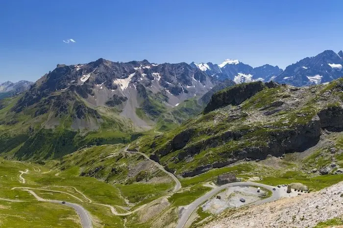
- The finale: the high mountains laid bare. Past Plan Lachat, the scenery suddenly changes. The road winds into a cirque of rock and silence. You turn right after a short flat section: this is where the real battle begins. There are 8 km left to the summit, averaging between 7 and 8.5%, punctuated by a few breaths in the hairpins. Then comes the last kilometer, after the Galibier tunnel: a constant 10%, thin air, short breath. Lucidity wavering. This is the realm of slowness, calculation, survival.
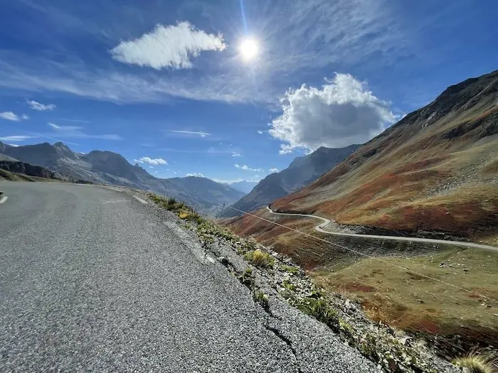
First wooded, then mineral, finally lunar, the Galibier concentrates all that the high mountains have of grandeur and harshness. The strongest climb it in 1h45 to 2h, the others cling on, eyes fixed on the eternal snows. Each bend carries the weight of a century of cycling: Coppi, Bahamontes, Pantani, Pidcock… And when the summit crest appears, fatigue dissolves into a strange clarity. The view of the Meije, the white light, the silence. The mountain here gives no quarter, but it offers a rare moment: that of touching the sky.
From Galibier to Chambon Dam: the penultimate chapter
Once the Galibier summit is crossed, you enter another world. The silence, the stark light, the Meije stretching on the horizon: it’s one of the most beautiful panoramas in the Alps, but also one of the most treacherous. The descent towards the Col du Lautaret is initially narrow, steep, often swept by the wind. The road winds through a lunar landscape, without trees or landmarks, and the gradient frequently exceeds 10%. The first kilometer demands humility and clear-headedness. Hands on the drops, eyes far ahead, especially if the temperature is low: here, even on July 19th, you can encounter snowdrifts. Past the Galibier tunnel, the road widens and the asphalt improves. Trajectories become more fluid, but speed quickly increases: 70 km/h is not uncommon. The Lautaret approaches, and with it, the promise of a breather.
From Lautaret to Chambon, it’s then the trap of the false flat descent. From the Col du Lautaret (2058 m), forget Briançon to the left for the road that plunges right for a long time towards the Romanche valley. About twenty kilometers of descending profile, but where you have to pedal almost relentlessly. Those who can shelter in a group will save precious energy; those who remain alone will slowly exhaust themselves. It’s a seemingly “easy” phase of the race, but one that devours the legs. The most clear-headed will take advantage of this moment to refuel, hydrate, and rest their minds before the last climb. The heat can be striking there, especially if the wind is contrary.
At this stage, the odometer shows over 125 km, and the legs are anything but light. As soon as you leave the Lautaret, the road opens up and invites you to accelerate. But the wind often makes an appearance here, particularly on the long straight sections from the Col du Lautaret to Villar-d’Arêne, then from La Grave to the Chambon tunnel. If it’s unfavorable, progress becomes slow, almost frustrating. The legs feel empty, and yet the bike computer only shows a 2 or 3% downhill gradient.
A classic trap: you think you’re “descending,” but you’re exhausting yourself trying to maintain race speed. The road is wide, well-maintained, with a few tunnels and galleries where the light changes abruptly. On-board lighting is recommended, if only for safety. There are few bends, but vigilance remains essential even during the Étape, where the road is closed and therefore safe for all participants. The landscape, however, remains sumptuous: the Meije on the left, suspended above the valley, like a movie set.
Past La Grave, the road follows the Romanche to the Chambon tunnel, at about 1,000 m altitude. This is a deceptively quiet section: the elevation gain slightly increases again, between 2 and 4%, for a few hundred meters. It’s the kind of gradient that doesn’t announce itself, but where watts melt away visibly. The legs, cooled by the descent, gradually become heavier.
The Chambon dam marks a break: here the valley closes, and the door to the final act opens. The lake, often a deep blue, hides beneath its surface the silence of past efforts. It is a place both soothing and unsettling: you know that by turning right, you leave the safety of the valley to plunge back into the mountains. This turn towards the Col de Sarenne is a symbol: it is that of choice. Straight ahead, the road descends back to Bourg-d’Oisans. To the right, the last battle begins.
To summarize: management and clear-headedness before Sarenne. It must be repeated: this transition is not a rest, it is a psychological trap. He who loses concentration here often loses everything. Those who ride intelligently, by refueling and managing their pace, will be those who still have a little light in their eyes at the finish. At that point, the odometer shows about 150 km and over 4,000 m of D+. Fatigue has set in, but the day is far from over. The road rises sharply as soon as you exit the tunnel, and many will be fooled by the illusion of a simple finale. The truth is that there are almost 25 kilometers left to cover, including 12.8 km of climbing at over 7% average.
The Col de Sarenne: the hidden face of Alpe d’Huez
Altitude: 1,999 m – 12.8 km – average gradient 7.3% – max 13%
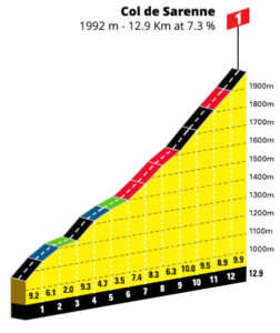
Sarenne is a wild finish, chosen by the organizer. No climb via the 21 mythical bends this year: A.S.O. has chosen to innovate, offering the side via the Col de Sarenne, Ferrand side. It’s a bold choice, reflecting this edition: a narrow, raw, gritty road, carved into the mountain. Here, no cheering crowds, no famous lines of bends: only the sound of the wind, the breath of the riders, and sometimes a few herds. An old-school, authentic, unvarnished finish. And from the first ramp, the tone is set: 1.5 km between 10 and 12%, without mercy. After more than 4,000 m of positive elevation already covered, this transition is of rare brutality. No false flat, no warm-up: the gradient attacks you from the start. For many, it’s the “mental wall” of the stage.
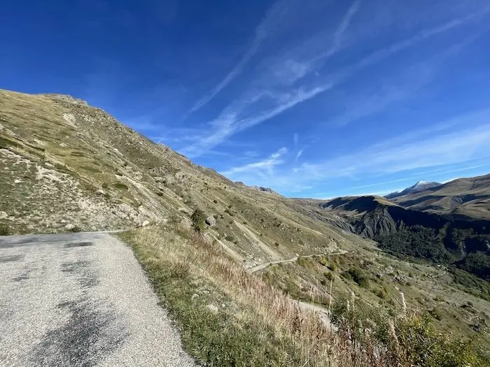
The Col de Sarenne is 950 m of elevation gain over 10.5 effective and relentless kilometers. But the numbers don’t tell the whole story: it’s an irregular, lively, unpredictable pass. The percentages vary without apparent logic, oscillating between 8 and 11%. The asphalt, sometimes rough, absorbs energy. The wind, often capricious, appears without warning on the summit section to glue you to the road if it’s present. The first half winds through a deep, cool, and silent gorge. Then, the road rises and opens onto the alpine pastures past Clavans le Bas: the light changes, breath becomes short, 2000 m are not so far away.
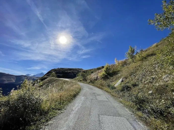
The Col de Sarenne is climbed as much with the head as with the legs. With accumulated fatigue and degraded asphalt: everything pushes you to give up. So you have to look up and contemplate. But it is precisely here that your memory of the Étape du Tour will be forged. The Étape du Tour with the most elevation gain since its creation in 1993! THE challenge!
The mountain tests, then rewards. Be careful, however, with the weather, always uncertain at this altitude. It is not uncommon for the pass to become covered in clouds in the late afternoon. We remember our participation in a Vaujany (late June) crossed under snow showers, face whipped, fingers frozen on the rim brakes. The Col de Sarenne does not forgive imprudence. Even in July, the mountain imposes its laws.
The finish at Alpe d’Huez: the ultimate breath
Once the pass is crossed, there will be a short, technical descent of 2 km, currently very treacherous, then a climb of 1 small km to the altiport, which will seal your ranking and your legs. Unlike the professionals, cyclosport riders will not go to the fork to take the last three hairpins of the classic climb. The finish will be directly after the altiport, after a small 1 km descent leading to Avenue du Rif Nel, the final point of this edition. A matter of logistics, but it changes nothing essential: the line is there, the symbol too.
A deceptive elevation gain, an extraordinary stage
From our point of view, the total announced elevation gain is slightly overestimated. The data communicated by A.S.O., approximately 5400 m D+, do not take into account tunnels or intermediate elevation changes. While various apps estimate the route at over 5400 m of cumulative elevation gain, we believe that it is closer to 5000 m. That’s already a significant challenge. In short, an old-school Étape du Tour… a day where victory will not be to cross the line first, but simply to cross it.
This 2026 edition revives tradition: that of long Alpine stages where managing one’s potential is paramount. A test of total endurance, both physical and mental, tailored for cyclists who love the mountains. Because beware, we repeat ourselves but the mountain cannot be tamed. The Croix de Fer, the Galibier, Alpe d’Huez: these are three names, three giants, three steps towards legend.
Our advice: clear-headedness above all
Don’t be too ambitious. If you have any doubt about your ability to free up time to train properly, skip this one and choose the Ventoux Étape instead. This 2026 edition adds nearly 1000 m of elevation gain and about thirty kilometers compared to recent editions. Plus the altitude and length of the passes. It’s a step up!
Honestly ask yourself how you finished at La Plagne in 2025: if it was on mental grit, if your legs were screaming for mercy, then this stage risks disgusting you. Knowing when to put your ego aside is also important.
The Galibier and Sarenne do not forgive lack of preparation — here, the mountain decides. The key is management: learning to climb for a long time without blowing up, to fuel correctly, to stay clear-headed when everything tightens up.
And for that, we can only encourage you to be coached by training specialists. As for me, you can find the training plans I wrote for A.S.O. and winter preparation tips on this link. Preparation starts now!
Good preparation to all and do not hesitate to ask your questions in the comments!
Share the post "Étape du Tour 2026: full reconnaissance"