Share the post "Strava enhances its maps"
Strava, the app for active people, announces the launch of two new heatmaps: Night and Weekly Heatmaps. These new features allow subscribers to make informed decisions when choosing their routes and to confidently adapt their adventures, taking into account the changing seasons.
Source: Press Release
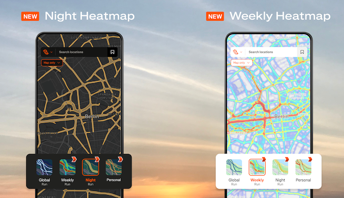
The Night Heatmap is useful for subscribers who engage in activities in the evening or early morning. It shows activity recorded between sunset and sunrise, allowing athletes to easily spot the most popular areas for outdoor activities during this period.
The Weekly Heatmap displays recent data from the last seven days, helping users stay informed about currently frequented trails and roads, especially during seasonal changes when conditions can be affected by the weather.
“Our global community powers our heatmaps, and we have now simplified route planning for our members, regardless of the season or time of day,” says Matt Salazar, Strava’s Chief Product Officer. “We are constantly improving our mapping technology to facilitate human-powered travel, whatever the level of athletic practice.”
Popular with users, the Global Heatmap can now be used to visualize the most frequented areas. With the addition of these new layers, the two new heatmaps demonstrate the platform’s commitment to providing subscribers with more tools to plan their outdoor activities and routes safely. With over 10 billion activities uploaded by 135 million users, Strava’s heatmaps offer a unique illustration of the movements of the global sports community and are one of many planning tools available on the platform.
Strava offers four different heatmap experiences:
- Night (New): to discover the most frequented areas between sunset and sunrise, ideal for those who practice in the evening or early morning.
- Weekly (New): data recorded over the last 7 days allows for adjusting routes based on seasonal changes or unforeseen closures.
- Global: the Global Heatmap allows users to see the most popular areas worldwide, based on community activities.
- Personal (Existing): a unique illustration showing the complete history of all GPS activities recorded by the subscriber. This heatmap is private and accessible only by the user.
The Global Heatmap is accessible to all Strava users, while the other three are reserved for subscribers, each offering unique perspectives to the active community. Strava’s public heatmaps use anonymized and aggregated data from public activities with visibility set to “Everyone.” Activities with “Only Me” or “Followers” privacy settings are automatically excluded from Strava’s public heatmaps.
To access the Night or Weekly Heatmaps on the Strava app or website, subscribers can click on the Maps tab and select the desired heatmap. For additional customization, subscribers can filter the heatmap by activity type or even display multiple heatmaps simultaneously. In addition to the new heatmaps, Strava subscribers can also enjoy other planning tools, such as suggested routes, route planning with photos and custom points of interest, as well as offline routes. Whether discovering new places to run or adapting to seasonal changes, Strava allows athletes to plan their next adventure with confidence, with information provided by a global community.
Share the post "Strava enhances its maps"