Share the post "Presentation of the Marmotte, 2023 edition"
With just a few days to go until the start of the Marmotte on Sunday, June 25, let’s take a closer look at what awaits the 8,000 participants on the roads of the oldest sportive.
By David Polveroni – Photos: All rights reserved
The Marmotte is the oldest French sportive, as in Italy, for example, the Nove Colli is older. However, this 42nd edition will be particularly marked by a significant modification to the original route.
While in the distant past, the finish was even in Vaujany, the main passes used were the Croix de Fer, the Galibier, and the finish at Alpe d’Huez. This was 174 km with 5000 m of elevation gain. Since 2005, the route has diverted slightly before the summit of the Croix de Fer, at the Glandon, to add a bit of valley, thus returning to roughly the initial distance and elevation. Even if the Glandon doesn’t offer the same scenery as the Croix de Fer, in terms of difficulty, it’s much the same with “only” 2 km more. But we’ll come back to that in more detail.
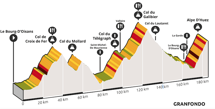
This year, the legendary route totals 187 km and 5500 m of elevation gain. On paper, this might seem almost anecdotal, but an additional 10% of elevation and distance (or almost) can sometimes significantly change the game and your effort management.
Indeed! This year, we return to the original route, bypassing the Glandon to climb the Croix de Fer, but we will have to detour via the Col du Mollard, a small joke… accompanied by a descent and then an ascent to finally return to the valley, which will have significantly drained your strength compared to previous years.
The Info
Bib number collection takes place at the event village at the Palais des Sports in Alpe d’Huez at the following times:
- Thursday from 2 p.m. to 7 p.m.
- Friday from 10 a.m. to 7 p.m.
- Saturday from 10 a.m. to 7 p.m.
You must bring the ticket received by email, along with a form of identification and your medical certificate if it has not been validated online.
In short, with your bib number in hand, you are registered for an event that is above all a personal challenge, because here, in the heart of Oisans: you will understand that the mountains will put you in your place.
The Race
By the time you read these lines, there’s no need to overthink your training; the dice have already been cast. You’ll have to draw conclusions later if you want to improve in this type of event. We’ll also let you adopt a nutritional strategy you’ve already used, or an “experimental” one for a future mountainous challenge.
Between 7 a.m. for the first starters, then 7:20 a.m. and 7:40 a.m. depending on your bib number, you’ll have to cover about ten kilometers on the flat at the start with a peloton of nearly 7,500 participants. A beautiful parade. A flat section, where the only stress is the risk of falling with the agitated riders who still haven’t understood that the race isn’t won here and that their position and risk-taking aren’t in line with their ambition…
In short, at Allemont, we find the first slopes that take us along the Verney dam, up above the EDF power station, past Vaujany on the right, a short descent, and then the real Marmotte begins!
In this type of event, you have to work in stages. Stages, then half-stages. While the Croix de Fer climbs for 28.5 km, this first stage is the ascent to Rivier d’Allemont, 5.6 km at an average of 8% but alternating between 10% and flat sections, making it irregular. However, from these first kilometers, you must adopt a pace that will be yours for the day.
Whatever your time goal, you’re going to spend several hours climbing, and if you want to finish, humility will be a beneficial character trait on this Marmotte, especially in 2023. So don’t overestimate yourself too much, and don’t try to follow a group or a person at all costs. These are events where going into the red pays dearly.
Once at Rivier, a small descent again breaks the rhythm if you look at the negative, but positively it allows you to catch your breath, two small kilometers of descent and then you start again this time for 1 km at almost 12%: we are in the thick of it… A detour taken since 1989 to bypass the landslide that had collapsed the road. After this very steep section, you find 7 km around 8%, alternating between 7 and 10, up to 1730 m altitude. This new high point will see the road run along the Grand Maison dam, a very beautiful lake! The view is necessary and barely time to appreciate the beauty of the place, that you can guess in the distance the last 2 kilometers of the Croix de Fer.
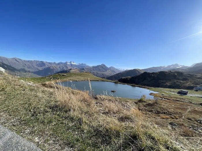
Before that, a short descent again, we pick up 2 km at 7% until the Col du Glandon. Here the wind can sometimes be quite strong; if it’s a headwind, being in a group is not a bad idea… We leave the old Marmotte route on the left to go to the Col de la Croix de Fer. 3 km, 6% fairly rolling, but given the elevation gain and the approach to 2000 meters, nothing is easy in the mountains.
After 39 km, we reach 2067 m at the first summit of the day, the Col de la Croix de Fer. Here the panorama is magnificent, the clock stops at the pass: refueling and contemplating the Aiguilles d’Arves is a good strategy.
Well, we’re in the race… So we continue our way down a few switchbacks on the roads previously used by the Critérium du Dauphiné, where a certain Vingegaard had won, descending to the village of St Sorlin d’Arves. A more rolling section follows where you sometimes have to pedal, along the Arvan, nestled between two mountains. We’ll leave a gas station on our right, let’s hope your tanks are still full (!) to cross the Belleville bridge and leave the main road to tackle the Col du Mollard.
The Col du Mollard
This is not an unprecedented passage, as in 2015 the Marmotte went through here (I was there!) but in the other direction. Here we start with 2 km at 8.5% before a transition of another 2 km between 4 and 5% to then find percentages again over the last 2 kilometers. This “small” Col du Mollard, at 1638 m altitude, cuts short any attempt at recovery as we could have had in the past by chaining Glandon/valley.
Almost want to say “fortunately” the descent of the Mollard which will begin will again be untimed. Always a headache, because this Marmotte will again turn into multiple hill climbs and you are never sure to be next to the person who will actually be next to you in the ranking… In short, you do it for yourself.
First part of the descent where you have to turn right after crossing Albiez Montrond to head towards Albiez le Jeune and then finally descend… 50 turns await you, where you have to relaunch the bike and be careful because the road is in some places in a rather precarious state…
You then arrive at Villargondran (quite happy…) and if you think you can then breathe a sigh of relief in a valley, think again! A small climb of 1.5 km to cut your legs once again! Some good sections at 10%. But hey, all this is just “child’s play” before what awaits you. But there you have it, you’ll have to deal with it. Another short descent and you finally pick up the small stretch of valley remaining behind the Maurienne factories. 8 km along the Arve, first on a false flat uphill then downhill to arrive at St Michel de Maurienne to then tackle the big section of the day: the Télégraphe – Galibier climb.
The Col du Télégraphe
With just under 12 km, 11,700 m on a road that will allow you to climb to leave the plain and find the mountains, that’s the idea! A climb that in itself would be almost insignificant but with already 90 km on the clock, you will already have to deal with inevitable fatigue. Not everyone is Pogacar!
The Télégraphe is divided into two parts: 6 sustained kilometers, 7/8% fairly constantly. The time of day will mean that the announced sun will make you shed a few drops of sweat… So remember to hydrate. I won’t detail any specific nutritional or hydration strategy, but on this type of event, it will make the difference between finishing in pain and finishing well… It’s all connected.
After these 6 km, we find easier percentages, 5/6, a slight 7 at the end before a final straight line overlooking the Arc valley to definitively enter the gates of the Galibier at 1566 m.
5 km of descent, a beautiful straight line where you often have to pedal, and you enter Valloire. A few meters in Paris-Roubaix mode, no doubt you remember this shaking passage, and then you immediately start the giant: the Galibier.
The Col du Galibier
No need here to imitate a Roglic or Pogacar attacking in turns last year with his teammate Vingegaard, then future stage winner and Tour winner. No, here you have to manage, you have nothing to gain… 17.6km and 1200m of elevation await us. Once again, you have to play in stages in this Galibier, a first section to get out of Valloire for 1.5 km, a good flat section where the refreshment stop was located last year, then again you have to manage until Plan Lachat.
This section, which climbs to just under 2000m altitude, can be quite treacherous if not managed well, a section where the wind is often a tailwind. You feel easy, but you don’t necessarily go fast… In short, here the scenery gradually changes, the mountains progressively engulf us… The vegetation becomes scarcer, the mineral aspect of the mountains takes over, but the air also diminishes.
Turning right, you can sometimes catch some wind, and you definitively enter what I call the Galibier at a place called Le Plan Lachat. There are 8 km of climbing left, 8 km to gain 650 m of elevation, with slopes between 7 and 9% up to the tunnel, before entering a double-digit world in the last hairpin to descend into a new valley. This climb has 2/3 turns at the beginning that either break your rhythm or allow you to catch your breath. Catch your breath, because that breath is getting shorter and shorter, which marks the difficulty of this pass is not its length or its slope but a combination of everything with the altitude. In short, here everyone is struggling, the very first who will be at the summit in less than 5 hours as well as the last, even if the latter will have spent a little more time in the saddle…
Advantage: the atmosphere here is simply magical, a climb where you feel your heart pounding against your chest, rhythmic with your breath and your pedaling cadence dangerously decreasing if you don’t make sure you’ve chosen the right gear and used your derailleur. Today, a 34×34 should be the rule for almost all participants. Better to have more than not enough.
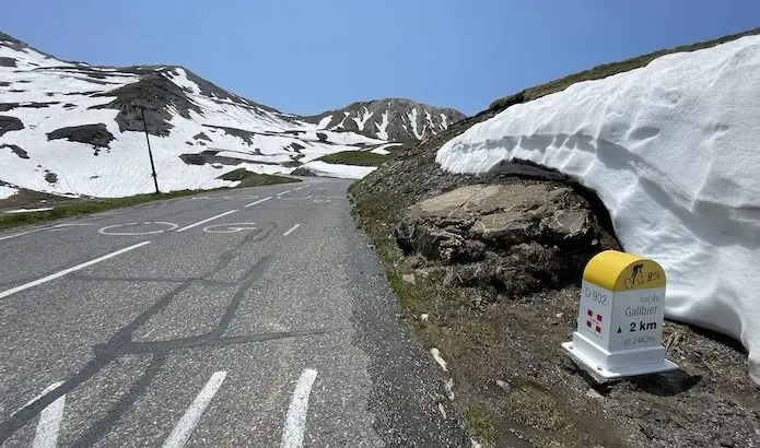
At 2642 m, the atmosphere is still a bit cool, amidst the snowfields. The pass was opened only a week ago, so wearing a small vest might be advisable, it’s up to you. What is mandatory is to put some fuel, some sugar, back into your machine. The Marmotte, more than any other event, makes you feel a gradual emptying of your reserves over the kilometers and elevation gain. So now, you will have to manage this almost 50-kilometer section to reach Bourg d’Oisans and tackle the climb to Alpe d’Huez with as much strength as possible.
Descent from Galibier to Bourg d’Oisans.
The first part of the descent to Lautaret will simply be to rest your legs; there’s no need to try to put your hand in your pocket here, but rather to be vigilant about your surroundings, as the road is still open… Fatigue reduces vigilance, coupled with altitude, the key word remains to be in control and not to get carried away by speed and sometimes tricky curves; we are in the mountains, the roads are not always perfect even if the Galibier is not the Mollard.
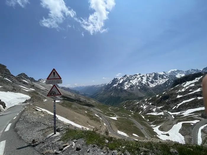
At the Col du Lautaret after 7 km, you need to take stock: here you have to wait for a group, 2/3 cyclists, otherwise let them go; you need to try to save as much energy as possible. Because this descent from Lautaret is anything but a free ride. Long straight sections, often with a headwind (if it was a tailwind in the Galibier before Plan Lachat: it’s a headwind on the descent, normally!) and small climbs after the Chambon dam. Before that, a few tunnels will require mandatory front and rear lighting as well as a reflective vest (otherwise participants not in compliance will be disqualified). This is also a section, more than an hour of cycling, where you really need to remember to reach into your pocket to arrive at Alpe d’Huez in the best possible condition and avoid running out of gas.
After a final tunnel in the Commères ramp, a last burst of speed before 5 km of flat to reach where it all began 170 km earlier: Bourg d’Oisans.
Alpe d’Huez
Turn left and then it’s off for almost 14 km and 1150 m of elevation gain… Here, you must avoid following those trying to imitate the US Postal train at the risk of blowing a gasket quite quickly. The first 2 kilometers up to La Garde are the hardest. 10/12% with only the hairpins to relieve the force applied to the pedals… Then you have to do everything to find the right tempo. 21 turns where for everyone here, the legs don’t turn like a Lance Armstrong or Tadej Pogacar and hurt. You have to tell yourself that this is the culmination of your day, of your goal for some, for many, that is looming.
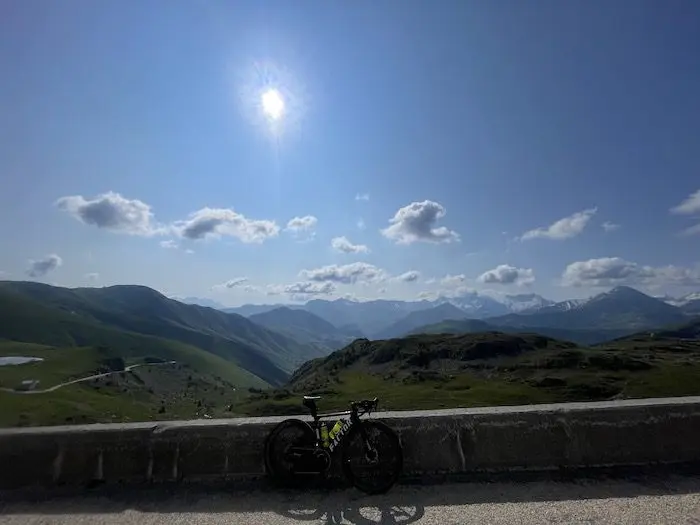
The mythical climb of Alpe d’Huez to conclude this beautiful day in the mountains: after passing the village of Huez (after the photographer ran after you to give you his card!), you can make out the last 4 hairpins. Turn 2, then 1, a final straight line, then you pass under a short tunnel before turning right again and arriving on a slight descent at the end of your Alpine mission!
Now all that’s left is to relive the race, the route with friends, those moments that are necessary to enjoy regardless of your satisfaction. Here in the heart of the island in the sun, admire these mountains around you one last time, think about your day, start to tell yourself what could have been improved… For next year?
https://marmottegranfondoalpes.com/lepape-marmotte-granfondo-alpes/#
Route: https://www.strava.com/routes/3106469197442745704
=> SEE ALSO: All our Travel articles
Share the post "Presentation of the Marmotte, 2023 edition"