Share the post "Reconnaissance of the 2020 Étape du Tour"
After five consecutive years in the Alps, the 2020 Étape du Tour sportive will once again stop in the massif, but a little further south this time. The event will take place 100% around the Nice-Cote-d’Azur metropolis between sea and mountains with exceptional views. Is this Étape du Tour easy? Not so sure, even if the passes to climb are not as mythical as in the past. David Polveroni, one of the best French sportive riders, recognized it exclusively for 3bikes.fr readers.
By David Polveroni and the editorial staff – Photos: David Polveroni and Colin Savioz.
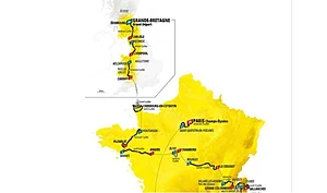
The 30th edition of the Étape du Tour sportive will take place on July 5, 2020 in Nice, one week after the Tour de France riders pass through the same course, during the second stage of a race that promises to be particularly mountainous this year. Amateurs will cover 177 km and 3,570 m of positive elevation gain in the Nice hinterland.
While the elevation gain seems relatively modest compared to the mileage (the 2019 edition, for example, had 4,500 m of elevation gain for 130 km), the distance should not be underestimated, even if there are no major passes over 2,000 m on the menu. Three passes will, however, serve as arbiters: the climb to La Colmiane, the Col du Turini used during the last Paris-Nice, then, to finish, the famous climb of the Col d’Eze before descending back to Nice.
For this reconnaissance during the last weekend of October, David Polveroni is accompanied by Colin Savioz, a 15-year-old young racer, already a formidable climber and winner of several timed climbs ahead of the Seniors in the Alps in 2019. A young talent to watch for sure!
| Colin Savioz (15 years old) – VC Froges Villard-Bonnot Overall victory at the René Vieto Memorial 2019 |
The two riders from Isère start the course on the famous Promenade des Anglais, five short kilometers along the Mediterranean coast before tackling the most monotonous part of this Étape du Tour. For thirty kilometers, long straight sections on the M6202, flat or slightly uphill, with the possibility of a slight headwind as during the reconnaissance. “This part, I think, will be decisive for the rest of the race,” says David Polveroni. “Whoever makes the least effort in this part while being as far forward as possible will have managed well. You can lose a lot here. Be careful.”
At Plan-du-Var, the route begins to leave “the plain” and gradually enters the Tinée valley, which is simply the foot of the famous Col de la Bonnette, the highest road in Europe. But we still have to wait 25 km, and already 55 km of riding before tackling the first ramps of the Col Saint-Martin, also known as: the climb of La Colmiane. We are just after the place called La Bolinette at 500m altitude.
Strava link for Col Saint-Martin.
This climb does not have steep gradients but will help to thin out the field. It is a steady climb around 6%, long and which can start to be difficult depending on how the participants have approached the first part. There is a very small ramp around 8/9% when crossing the village of Valdeblore preceded by a flat section. Nothing too bad. You just have to find your own tempo. At the summit, at just over 1500m altitude, we are already more than 3 hours into the ride, at least for our reconnaissance. “I think here you have to know how to conserve energy and find a group of your level in order to save some for the rest of the course,” David Polveroni adds.
A fast descent, a wide road where it is possible to pick up speed, without traps. The curves are beautiful. The rest is a little more relaxing. The route then crosses Saint Martin de Vésubie after 7 km, which is the northernmost point of this Étape du Tour. We continue this descent of the Vésubie Valley, and thus begin the return to Nice. But first, we have to make a detour via the Col du Turini.
93 km covered from Nice, this is the foot of the Col du Turini, the second difficulty of the day. This pass is similar to La Colmiane in its first part, but it becomes increasingly difficult, especially as the efforts begin to take their toll.
Strava link for Col du Turini.
A first section of 3 km in switchbacks at 5/7% up to the village of La Bollène Vésubie, a small flat section when crossing, then a second section of 12 km, where the percentages range between 7 and 9% at most.
Nevertheless, even if we are not in a long Alpine pass, the weariness begins to be felt on this section. The summit might seem distant, at a little over 1600 m altitude if efforts have been poorly managed. “Once the summit is crossed, be careful, it doesn’t descend immediately,” specifies our ambassador. “There is still a small kilometer of slight false flat, then a plateau of about 7 km with the crossing of Peira Cava. During our reconnaissance, this part was covered with thick gravel on the first section, I hope it won’t be the same on July 5th!”
Finally, the route begins the real descent and plunge towards Nice. First, a first part with many switchbacks (16 in 5 km), which undoubtedly offer the most beautiful panorama of this stage. A gentle slope, so you don’t pick up much speed between the curves. You will have to negotiate them well. The descent continues to Lucéram, a little faster, with some curves but no traps. After Luceram, the circuit returns to a slightly wider road until L’Escarène. We cross the village, then a small kick (1 km) leads us to the Col de Nice, before gradually arriving in the outskirts of Nice, Cantaron, Drap, all on a false flat descent.
From Luceram to the entrance of Nice, this is therefore a favorable section to refuel and recover, always provided you are in a good group. A solo rider is likely to lose energy. As much as the first part to Luceram is pure descent, after that being grouped will be decisive.
The route goes up Boulevard Saint-Roch, and it’s off for the last climb of this stage: the mythical Col d’Eze.
It’s not Val Thorens, but it hurts at the end of the course. It’s an irregular climb. A first part of 3 km at 7/8% (slight flat after 2 km), a rolling section of 3 km at 3%, then a second part of 2 km at 7/8% before finishing with 2 km almost flat. The route then finds a descent on the Grande Corniche road, very wide, with a perfect surface and large curves where you still have to pedal to reach the old port of Nice and finally the Promenade des Anglais, which we had left a few hours earlier.
After this reconnaissance, David Polveroni gives us his opinion and his final advice: “This Étape du Tour is quite tricky for climbers in its first part, as it will allow all types of riders to gain an advantage and try their luck. In general, this course is a notch below in terms of difficulty compared to recent editions: no steep gradients, no high altitude, no very long passes (although there will be very little respite from the start to La Colmiane). Nevertheless, you will need good endurance because this stage is long (expect about 35 to 50 minutes more effort compared to 2019). You will therefore need to train accordingly, manage your efforts well until Turini, then recover as much as possible until Nice, and give it your all for Eze. I do not recommend any particular gearing for this stage. What you use to climb a 7/8% pass will be sufficient.”
Strava link for the entire reconnaissance
Share the post "Reconnaissance of the 2020 Étape du Tour"